Consuming the WMS in GIS
Of course, consuming the WMS output in a web browser is not very user-friendly. But you can use any open standard WMS-compliant client, for example QGIS or ArcMAP, to use this WMS as a layer source. Try one of these methods below (using either QGIS or ArcMAP, whatever you prefer).
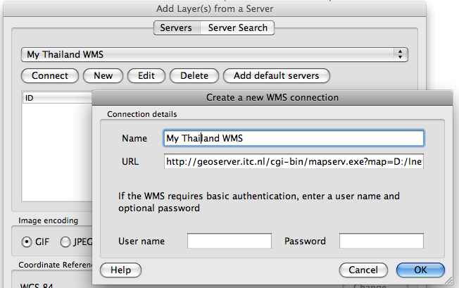
Using QGIS to consume WMS layers
The Open Source QGIS also supports many OGC services. Follow the steps below to connect to your Thailand WMS:
-
Choose the
Layer > Add WMS/WMTS Layer...menu or click the WMS layer icon. You can choose an existing Server Connection from the list, or add your own WMS connections to this list: Click theNewbutton. In theNamefield you can give any name for the connection you want. - Now you ONLY provide the so--called root URL: This is the 'bare' path to the service, to which QGIS can add its own parameters. Use this URL:
https://gisedu.itc.utwente.nl/cgi-bin/mapserv.exe?map=[NETPATH]/configWMS.map& - Once you have selected it and clicked the
Connectbutton, the software sends the GetCapabilities request to the WMS. The resulting XML description of the capabilities of the service will be parsed by QGIS and it will display the layers that were advertised as being available. - Select the layer you want to show (and if necessary its SRS and outputformat). The WMS map wil be added as a (raster) layer in your interface. You can zoom in and out and combine it with any other data.
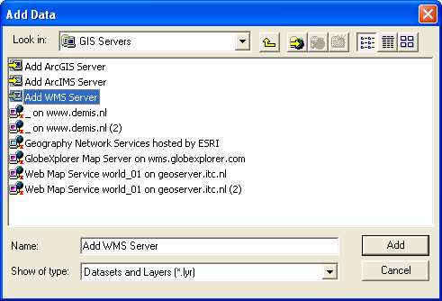
Using ArcMAP to consume WMS layers
ESRI provides different options to access web services. ArcMAP is one of these, where you can view WMS together with local data and also combined with proprietary ArcGIS Map Server services. To achieve this you can follow these steps:
- Start ArcMap. Choose 'Add Data' and choose 'add WMS Service' from the 'GIS Servers' group.
- Now you ONLY provide the so--called root URL: This is the 'bare' path to the service, to which ArcMAP can add its own parameters. Use this URL:
https://gisedu.itc.utwente.nl/cgi-bin/mapserv.exe?map=[NETPATH]/configWMS.map& - Click the
Get Layersbutton: ArcMap will add the appropriate parameters to the door URL to make a GetCapabilities request. It then parses the XML response, and presents the results (e.g. the available layers) to you. Choose the layer you want and clickOK.